|
The Other Path
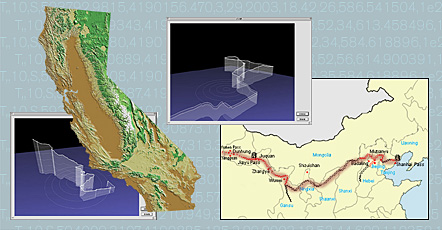
Throughout the world there are paths of significant historical, cultural and strategic implication. One such intriguing path is the Great Wall of China. The objective of The Other Path is to locate and describe the twin other of this significant path. The Great Wall of China, one of the largest building-construction projects ever carried out, stretching for nearly 2,000 miles from the shores of the Yellow Sea to the Gobi Desert, is a monumental Geographic Information Systems (GIS) mapping enterprise. This ancient technological artifact provides an excellent opportunity for creating an arena of exploration and representation uniquely enabled by contemporary GIS technology. This venture does not come without challenges: sheer length and challenging terrain.
In the spring of 2004, C5 set out on a month long Great Wall trek starting in the northwest desert of China and following the Wall eastward to where it runs to the edge of the Yellow Sea. GPS data, collected from twelve separate trekked locations along the length of the Great Wall, was used to develop pattern-matching search procedures for locating the most similar data model in the most similar terrain in California. The first phase of the search process was locating the closest counterpart in a one-kilometer-square area containing a correspondent start point for each of the Great Wall GPS tracks. In this initial search algorithm the elevation of the points in the China GPS tracks were used as a sample set to infer the characteristics of the terrain in 1K areas, using a standard deviation formula. The search was conducted on California Digital Elevation Model (DEM) data stored in increments of 1K-square blocks in the C5 Landscape Database.
After determining the blocks representing the most similar terrain in California, phase two of the Other Path search process was identifying paths within those terrains expressing similar statistical characteristics, such as simple distance, cumulative distance, and elevation change. To do this, a swarm of virtual hikers, implemented as experimental features of the C5 Landscape Database Application Interface (API), were unleashed in the virtual California landscape to explore and generate tracklogs, which were then compared to the original "input" Great Wall of China tracklogs. The results of this search identified the most closely matching virtual tracklogs, which were then exported to tracklog files, uploaded to GPS devices, and then physically followed by C5 in a performance of tertiary exploration of the Great Wall of California.
View exhibition documentation of The Other Path, from The C5 Landscape Initiative debut exhibition at San Francisco Camerawork.
|