| The C5 Landscape Initiative
In 2001, C5 initiated a series of projects involving mapping, navigation and search of the landscape using GIS (Geographic Information Systems). The projects are designed to take place over 5 years and are an extension of C5's exploration into data visualization systems as art. The Landscape Initiative examines the changing conception of the Landscape as we move from the aesthetics of representation to those of information visualization and interface.
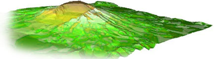
Over the past decade the instrumentation necessary for creating a detailed mapping of the earth's surface from space has become a reality. The USGS together with NASA, The Jet Propulsion Laboratory and a host of international partners are moving towards a complete mapping of the earth's surface destined to be at one meter of resolution. Like the human genome, the scope and implication of such a mapping points to tremendous social, political and economic considerations. Conception and interaction with the Landscape is becoming an issue of database. Technology transfer from GIS research activities incorporates new data products such as those in environmental studies, including strategic management of resources and hazards and disaster analysis. New discourses and disciplines have emerged around topics such as interactive mapping and archeological geophysics. The technologies of Spatial Data Systems and GPS (Global Positioning System) have enabled an entirely new relationship with the Landscape that takes form in applications for simulation, surveillance, resource allocation and management of cooperative networks. It is in this context that the C5 Landscape Initiative was conceived.
Presently, the flow of information to this is relatively limited and the commodity value high. Recognizing this fact, an important objective of the Landscape Initiative is the making available of open source software produced by C5 which will allow anyone to pursue the trajectories enabled by these projects.
|